Galápagos · Isabela
The Sierra Negra Volcano Hike, Galápagos: Trail Guide
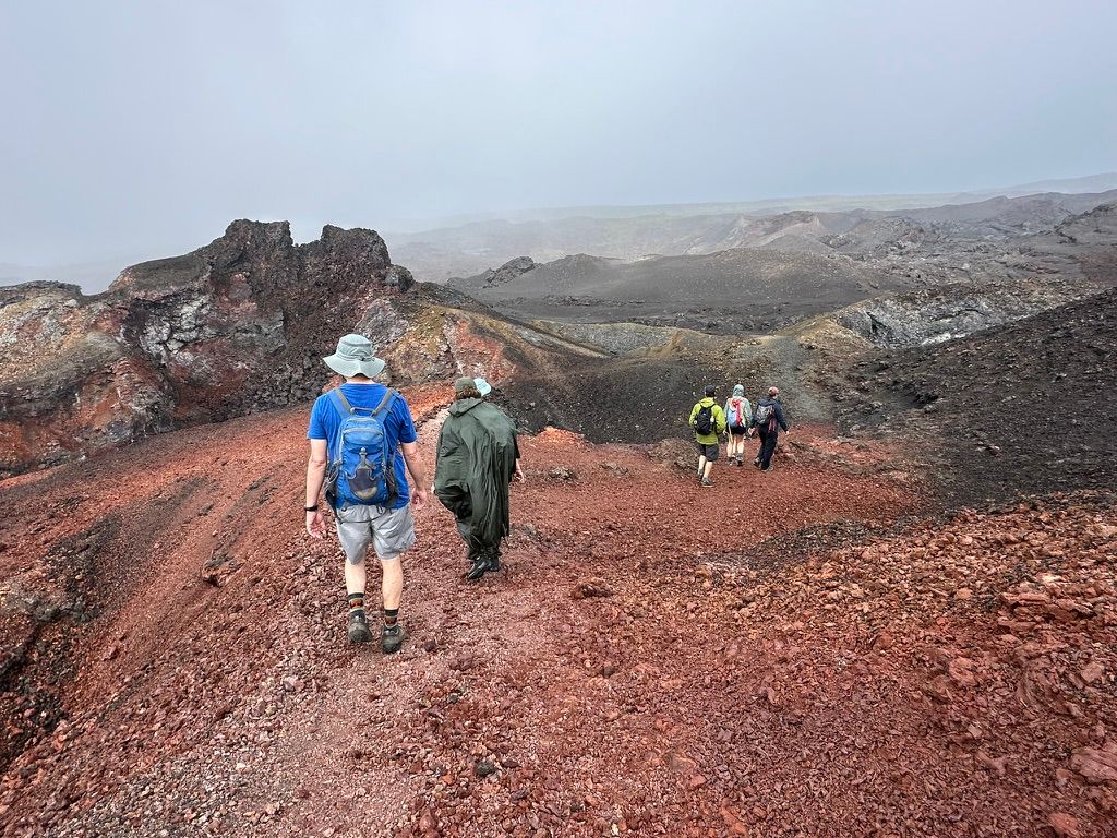
If you do one hike in the Galápagos, make it Sierra Negra. On Isabela Island sits one of the largest active calderas on Earth, and a trail leads right to its rim and on to the surreal, steaming lava fields of Volcán Chico. It’s the single best reason to experience the islands on foot, land-based rather than only from a boat — and below is the honest trail brief, with the numbers other guides get contradictory.
Quick facts
| Where | Isabela Island, Galápagos (highlands above Puerto Villamil) |
| Distance | ~16 km round trip (rim + Volcán Chico) |
| Time | 5–6 hours |
| Difficulty | Moderate — distance & heat, not the climb |
| Elevation | Max ~1,124 m · modest gain (not a high-altitude climb) |
| Caldera | ~10 km across (~30 km around) — one of Earth’s largest active |
| Guide | Required (national-park rule) |
| Best time | Year-round; drier underfoot Jun–Nov |
What is Sierra Negra?
Sierra Negra is a massive shield volcano — broad and gently sloping, built up over ~500,000 years from runny basaltic lava — and one of five shield volcanoes that form Isabela Island. Its caldera is so wide that standing on the rim you can’t take it all in: a black sea of solidified lava stretching to the far wall.
You’ll see its size quoted two different ways, which trips a lot of people up: it’s roughly 10 km across (its diameter) and about 30 km around (its circumference) — both are right, and it’s one of the largest active calderas on the planet. It last erupted in 2018 (before that, 2005), so you’re literally walking on some of the youngest ground on Earth.
The hike, segment by segment
The trail changes character as you go — that’s part of what makes it so good:
- Trailhead → caldera rim — a steady walk on a dirt road and then trail through humid highland scrub. After rain this first stretch gets muddy and slippery (the one genuinely awkward part). You climb gently to the caldera rim, where the whole black basin opens up.
- Along the rim — the trail skirts the edge with the caldera dropping away beside you.
- Rim → Volcán Chico — the trail crosses open, exposed lava out to the Volcán Chico vent area. Little shade, full sun, otherworldly ground.
Most people do the full route to Volcán Chico and back — about 16 km, 5–6 hours. Turning back at the rim makes it noticeably shorter, but you’d miss the best part.
Volcán Chico — the part you came for
Volcán Chico isn’t a separate volcano; it’s a parasitic vent on Sierra Negra’s flank, and it’s the highlight. Here the lava is young and vivid: fields of red, ochre and yellow basalt in two textures geologists call pāhoehoe (smooth, ropey) and a’ā (sharp, broken). Fumaroles hiss sulphurous steam from cracks, and the views stretch over Isabela to the sea. It feels like another planet — and it’s where every good Sierra Negra hike turns around.
How hard is it, really?
Honestly: moderate, but rarely for the reason people expect. There’s very little steep climbing — the elevation gain is gentle. What gets people is the combination of distance, equatorial heat and walking on lava rock, plus the muddy start after rain. If you can comfortably walk 16 km on a hot day, you’ll be fine. It is not a high-altitude climb like Cotopaxi or Chimborazo on the mainland.
Do you need a guide?
Yes. Sierra Negra is inside Galápagos National Park, and a licensed naturalist guide is required for the trail — there’s no walking it independently. That’s a feature, not a hassle: the guide reads the weather, knows the lava terrain, and brings the geology and ecology of an active volcano to life. We arrange exactly this (guide, transport from Puerto Villamil, boxed lunch) as part of a land-based itinerary.
What to bring
- Water — at least 2 litres; there’s no shade and nowhere to refill.
- Sun protection — hat, sunscreen, sunglasses; the lava radiates heat.
- A light rain layer — the highlands catch passing showers.
- Sturdy shoes with ankle support and grip — the lava is sharp and the wet-season start is slippery.
- Long sleeves and snacks; your trip usually includes a boxed lunch.
Best time to hike Sierra Negra
It’s a year-round hike. The cooler, drier garúa season (roughly June–November) means firmer footing on that muddy first stretch; the warm season (December–May) is sunnier but wetter underfoot. Either way, start in the morning to beat the worst of the heat on the open lava.
One honest note: Sierra Negra is a geology hike, not a wildlife hike. You’ll see endemic plants and Galápagos hawks, but if it’s tortoises and boobies you’re after, pair it with the Wall of Tears trail lower down.
How it fits a multi-day Galápagos hike
Sierra Negra is the centrepiece of a day on Isabela. It pairs naturally with the Wall of Tears and the island’s beaches and lagoons — see the full plan on our Isabela hiking page — and slots into a multi-day, land-based Galápagos hiking itinerary that also takes in Santa Cruz and San Cristóbal.
Want to walk the Galápagos instead of just cruising past it? Our Galápagos hiking trips are built around exactly this.
Frequently asked questions
How long is the Sierra Negra volcano hike?
About 16 km round trip if you include the Volcán Chico extension — roughly 5–6 hours of walking with stops. The hike to the caldera rim and back alone is shorter (around 9–10 km); almost everyone continues to the Volcán Chico lava fields, which is the best part.
How difficult is the Sierra Negra volcano hike?
Moderate, but not for the reason you'd think. There's very little climbing — the elevation gain is modest. What makes it tough is the distance, the heat and the lava rock underfoot, plus a muddy, slippery start in the wet season. Reasonably fit walkers handle it fine.
Can you hike Sierra Negra without a guide?
No. Sierra Negra is inside Galápagos National Park, and a licensed naturalist guide is required by law for the trail. It's not just red tape — the guide handles the weather, the lava terrain and the geology. We arrange it as part of a land-based itinerary.
When did Sierra Negra last erupt — is it still active?
Sierra Negra last erupted in 2018 (before that, 2005). It's still an active shield volcano, with steaming fumaroles at Volcán Chico, but it's safely hikeable — eruptions are monitored and infrequent. You're walking on some of the youngest land on Earth.
What type of volcano is Sierra Negra?
It's a shield volcano — broad and gently sloping, built from runny basaltic lava — and home to one of the largest active calderas in the world, roughly 10 km across. It's one of five shield volcanoes that make up Isabela Island.
What do you see on the Sierra Negra hike?
The vast black caldera from the rim, then the multicoloured lava fields and steaming fumaroles of Volcán Chico — red, ochre and yellow rock in surreal shapes. Endemic plants reclaim the lava, and Galápagos hawks often circle overhead. It's a geology hike first, wildlife second.
How do you get to the Sierra Negra trailhead?
The trailhead sits in the highlands above Puerto Villamil, about a 30–45 minute drive from town. A land-based trip includes the transport, the guide and usually a boxed lunch, so you just walk.
Is Sierra Negra worth it?
Absolutely — it's the best day hike in the Galápagos and the main reason to spend a day or two on Isabela on foot. If you love dramatic landscapes and active geology, nothing else in the islands compares. (It's light on big wildlife, so come for the volcano.)